Planes & Trains | Buses | Shuttles
Directions
Driving
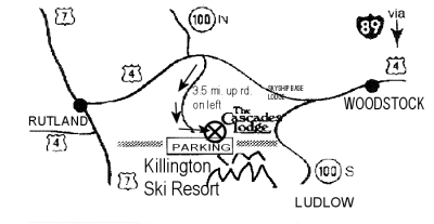
to Killington easy. Killington is located in Central
Vermont at the junction of US Route 4 and Vermont Route 100, just 11
miles East of Rutland. From the Southwest, connecting to the
Adirondack
 Northway
(I87) is less than an hour away, and from the Southeast, connecting
with I91 or I93 via I89 is also about an hour from Killington. (see
the red x on the map to the right, for our
location.)
Some examples of mileage and travel times:
| City | Hours | Miles | |
|---|---|---|---|
| Albany | 2 ¼ | 110 | |
| Boston | 3 | 155 | |
| Buffalo | 7 | 375 | |
| Cleveland | 10 | 575 | |
| Hartford | 3 ¾ | 160 | |
| Manchester, NH | 2 | 115 | |
| Montreal | 3 ½ | 185 | |
| New York, NY | 5 | 250 | |
| Philadelphia | 6 ½ | 330 | |
| Rochester | 6 | 320 | |
| Springfield, MA | 2 ½ | 140 | |
| Syracuse | 4 ¾ | 285 | |
| Toronto | 9 | 470 |
Directions To The Cascades Lodge, in Killington, Vermont
Final, Detailed Directions to The Cascades Lodge and the Killington Basin.
From the West - Approaching the Resort from Rutland:
Go 14 miles East.
(When you pass the PICO SKI ENTRANCE, you will need to travel 2
miles further on Route 4 East.)
You will notice that Route 100 North goes to your left. Ignore this,
and see that you are now in front of the Killington Chamber of
Commerce on your left side. Turn Right
after Killington Outfitters. This is the Killington Road. Drive up
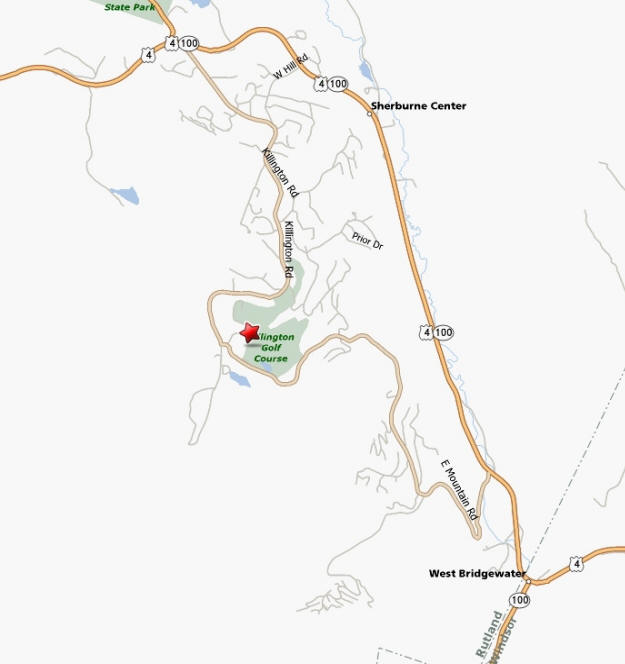
the Killington Road about 4 Miles. When you enter Calvin Coolidge
State Forest, you will begin to see direction signs on the right
side of the road. One of the first signs will point to lodging and
golf course to your left. Take this left turn. Go about 50 feet,
then turn left again. The Cascades Lodge is right in front of you.
Bear Right into our check in area. See Map.

From the East - Approaching the Resort from Woodstock:
| Be Alert. West Mountain Road is very difficult. Do Not Turn off Route 4 and 100 at the Skyeship Gondola Station. Go another 4.5 miles West to the Killington Road, opposite Bill's Country Store, just before Route 100 North turns right. It is much easier. |
Go 20 miles West from Woodstock, VT, on Route 4 West.
(At 15 Miles, you should have entered the junction of Routes 4 West
and 100 North. Then pass under the walkway at Killington's Route 4
Skyeship Station. Continue the remaining 4.5 miles along Routes 4 &
100)
At this point, you should be at the intersection of The Killington
Mountain Road (on your left) Killington Chamber of Commerce (on your right)
Route 100 North turns to the right, Route 4 heads straight towards
Rutland.
Turn left at Killington Chamber of Commerce, keeping The Killington Outfitters
on your right. You are now on the Killington Road. Drive up the
Killington Road about 4 Miles.
When you enter Calvin Coolidge State Forest, you will begin to see
direction signs on the right side of the road. One of the first
signs will point to lodging and golf course on the left. Take this
left turn. Go about 50 feet, then turn left again. We are right in
front of you. Bear Right into our check in area. See Map Above.
From the South - Approaching the Resort from Ludlow: (Distance from Ludlow to the Killington Road Entrance: 28.2 Miles)
| Be Alert. West Mountain Road is very difficult. Do Not Turn off Route 4 and 100 at the Skyeship Gondola Station. Go another 4.5 miles West to the Killington Road, opposite Bill's Country Store, just before Route 100 North turns right. It is much easier. |
28 Miles North of Ludlow, VT, on Route 100 North
(At 23 Miles, you should have entered the junction of routes 100
North and 4 West. Then pass under the walkway at Killington's Route
4 Skyeship Station. Continue the remaining 4.5 miles along Routes 4
& 100)
At this point, you should be at the intersection of The Killington
Mountain Road (on your left) Killington Chamber of Commerce (on your right)
Route 100 North turns to the right, Route 4 heads straight towards
Rutland.
Turn left at Killington Chamber of Commerce. You are now on the Killington Road. Drive up the
Killington Road about 4 Miles.
When you enter Calvin Coolidge State Forest, you will begin to see
direction signs on the right side of the road. One of the first
signs will point to lodging and golf course on the left. Take this
left turn. Go about 50 feet, then turn left again. We are right in
front of you. Bear Right into our check in area. See Map Above.
